Variometer-Sky Land (Trial)
Đã cập nhật
Phiên bản hiện tại
25.9
Cung cấp bởi
![]()
Bạn không cần phải lo lắng về việc sạc quá mức khi sử dụng Variometer-Sky Land (Trial) trên điện thoại của bạn, không phải sử dụng trên màn hình nhỏ bé và tận hưởng ứng dụng trên màn hình lớn hơn rất nhiều. Từ bây giờ, bạn hãy trải nghiệm ứng dụng của bạn toàn màn hình bằng bàn phím và chuột. MEmu cung cấp cho bạn tất cả các tính năng đáng ngạc nhiên mà bạn mong đợi: cài đặt nhanh, cài đặt dễ dàng, điều khiển trực quan, không còn giới hạn về pin, dữ liệu di động và các cuộc gọi làm phiền. MEmu 9 hoàn toàn mới là sự lựa chọn tốt nhất để sử dụng Variometer-Sky Land (Trial) trên máy tính của bạn. Được mã hóa với sự hợp nhất của chúng tôi, trình quản lý multi-instance giúp mở 2 tài khoản trở lên cùng một lúc. Và điều quan trọng nhất là, công cụ mô phỏng độc quyền của chúng tôi có thể tận dụng hết toàn bộ tiềm năng trên PC của bạn, giúp mọi thứ vận hành trơn tru và thú vị.
Nhiều hơn
Tải Variometer-Sky Land (Trial) trên PC với Trình giả lập Android MEmu. Tận hưởng trải nghiệm chơi game trên màn hình lớn This app always knows and uses the current location even when running in the foreground as well as in the background.
This app always knows and uses the current location even when running in the foreground as well as in the background.
This is a trial version with a limited time limit.
This app is a full-featured Trial version.
Approved CIVL flight instrument for FAI Category 1.(https://www.fai.org/page/civl-xc-instrument-accepted)
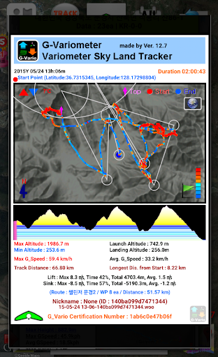
Variometer, Vario, G_Vario, G_Variometer, Tracker (Compatible for GPS only or Phone Baro Sensor or FlyNet2 or BlueFlyVario or GoFly Pico), 3D Track View with 3D terrain maps.
Paragliding, hang gliding and all air sports, Radio Control Plane and skiing, sailing, mountain climbing, etc.
Portal tracker instruments for all Outdoor sports.
Support Offline map as MapsForge(.map) offline map
Support FAI-CIVL(http://vali.fai-civl.org/supported.html) valid IGC files. (GNSS : http://g-variometer-vali.blogspot.kr)
Flight instruments is expensive, but your phone is also expensive equipment.
Your phone is better than that , you can perform a variety of functions.
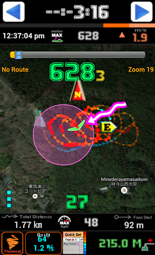
Using Compass & GPS & Pressure Sensor, flight time, speed, altitude, vertical speed, L/D is displayed.
If your phone is equipped with pressure sensor, In air sports mode, variometer functions can be maximized.
Pressure Sensor sensitivity of this filter using the Fourier Transform is better than any other filter using a simple lowpass filter or kalman.
Therefore more precise user setting is possible.
After simple one click, Ready to take off at once, auto-start-stop, manual-start-stop is possible
Big font and high contrast raised the visibility in outdoor.
Through manual built in the app, you can learn easily how to use.
Flight time, battery level, GPS status, and vertical speed, maximum speed, speed, maximum altitude, altitude, Hpa pressure, temperature (varies by altitude), weather (wind direction, wind speed), Task orientation, remaining distance, the total path length, Fuel Gage(for Motor Skysports) are displayed
It displays the direction and intensity of drift and thermal detecting also.
Waypoint and Route creation is easier and faster than any other app.
Waypoint Import Export Support (WPT, CUP format)
Map of the Google, OSM, GoogleV2 is used in various ways.
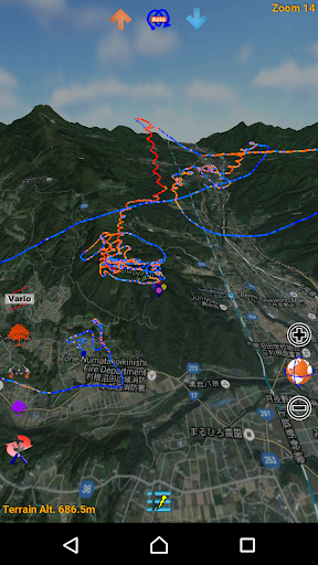
Track play function is best function same as seeing the actual flight.
Indexing and rewinding and the execution speed can be adjusted.
You can also see in 3D Track(shared track) with 3D terrain maps(shared track).
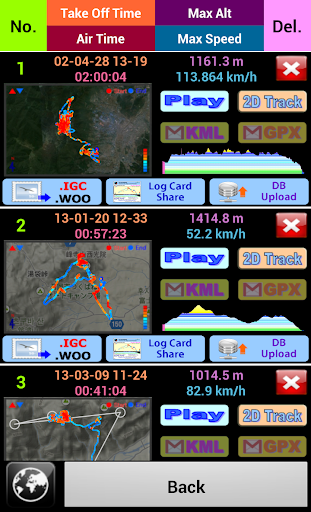
Seeing track thumbnail, you can easily find a specific flight record and
Your indexing speed can be also fast through altitude graph.
Track files can be sent via email to other users and
In addition, KML, GPX files are saved and automatically converted.
Navigation displays to the users the real-time shortest course from the current location and flight direction to next task, remaining distance, needed altitude against glide ratio
In briefing, share discussion with colleagues easy.
The units (mile, feet, meter, knot, ft / s, m / s, mph, kph, ℃, ℉) can be freely selected.
Coordinate system of the DD-MM-SS.SS, UTM, WGS84, etc can be selected
When performing in background Mode, track can be recorded throughout the day precisely and
During the mode, the sonic variometer functions and task passing, starting height sound alarm can be performed continuously.
The altitude can be set in a variety of ways.
Based Terrain Elevation, sea level air pressure reference, GPS altitude, the user manual setting is possible.
GPS environment will be best in flight, You can get reliable performance.
The following specific rights are
android.permission.ACCESS_GPS
android.permission.GET_ACCOUNTS
Direct GPS connection is required due to FAI IGC file creation regulations,
We use a user account to make it convenient for you to share your track files.
For feature requests and uncomfortable, please send mail to.
airfoil.hangglider@gmail.com
Nhiều hơn

1. Tải trình cài đặt MEmu và hoàn tất cài đặt

2. Khởi động MEmu, sau đó mở Google Play trên trang chủ

3. Tìm kiếm Variometer-Sky Land (Trial) trong Google Play
4. Tải và Cài Đặt Variometer-Sky Land (Trial)
5. Khi cài đặt hoàn tất, nhấp vào biểu tượng để bắt đầu

6. Trải nghiệm Variometer-Sky Land (Trial) trên PC của bạn bằng MEmu
MEmu Play là trình giả lập Android miễn phí tốt nhất, với 50 triệu người dùng trải nghiệm ứng dụng Android tuyệt vời. Công nghệ ảo hóa của MEmu cho phép bạn chạy mượt mà hàng ngàn ứng dụng Android trên máy tính, ngay cả những ứng dụng đòi hỏi cấu hình cao nhất.
Màn hình lớn hơn cùng với đồ hoạ tốt hơn; thời lượng dài, không giới hạn về pin hoặc dữ liệu di động
Hỗ trợ đầy đủ Keymapping cho việc kiểm soát chính xác bàn phím và chuột hoặc gamepad
Nhiều tài khoản trò chơi hoặc tác vụ cùng lúc trên một PC với Quản lý Đa năng
Use Variometer-Sky Land (Trial) on PC by following steps: