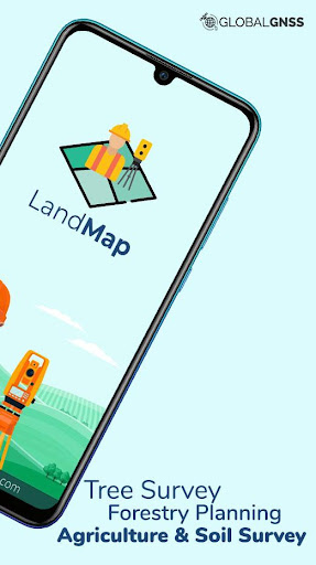
Land Map - GPS Land Survey & M
อัปเดตเมื่อ
เวอร์ชันปัจจุบัน
1.3
ให้บริการโดย
![]()
เมื่อใช้ Land Map - GPS Land Survey & M บนโทรศัพท์ของคุณไม่ต้องกังวลกับการชาร์จไฟมากเกินไปปลดปล่อยตัวคุณเองจากหน้าจอขนาดเล็กและสนุกกับการใช้แอพนี้บนหน้าจอขนาดใหญ่ จากนี้ไปรับประสบการณ์เต็มหน้าจอของแอปพลิเคชันของคุณด้วยคีย์บอร์ดและเมาส์ MEmu มีคุณสมบัติที่น่าแปลกใจที่คุณคาดหวัง: การติดตั้งที่รวดเร็วและการตั้งค่าที่ง่ายควบคุมได้ง่ายไม่ จำกัด แบตเตอรี่ข้อมูลมือถือและการโทรที่รบกวน MEmu 9 ใหม่ล่าสุดเป็นตัวเลือกที่ดีที่สุดสำหรับการใช้ Meitu – โปรแกรมแก้ไขภาพแนวธรรมชาติ บนคอมพิวเตอร์ของคุณ ด้วยรหัสการดูดซึมของเราผู้จัดการหลายอินสแตนซ์ทำให้สามารถเปิดบัญชี 2 บัญชีขึ้นไปในเวลาเดียวกันได้ และที่สำคัญที่สุดเอ็นจิ้นจำลองพิเศษของเราสามารถปลดปล่อยศักยภาพของPCของคุณและทำให้ทุกอย่างราบรื่นและสนุกสนาน
แสดงเพิ่มเติม
ดาวน์โหลด Land Map - GPS Land Survey & M บน PC ด้วย MEmu Android Emulator สนุกกับการเล่นบนหน้าจอขนาดใหญ่ This Survey Application is a paid application.

This Survey Application is a paid application. We would really appreciate if you could reach us with your issues before rating us.
To raise a ticket, find the link at the bottom↓↓
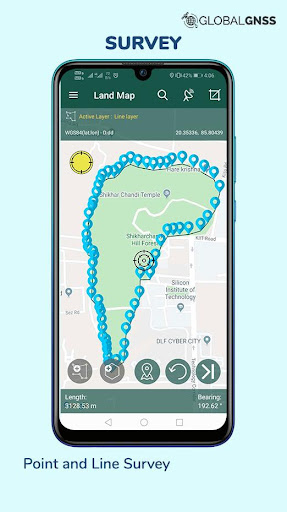
Land map is an application for surveyors. Precision and accuracy are the two cornerstones that enables Land Map for GIS survey, GIS Data handling, data collection, and analysis.
The applications UI enables faster data collection while the software allows to work in numerous file formats like CSV, KML, and GeoJSONwhich helps in GIS Mapping.
Land Map is a GPS/GNSS based survey application that uses GPS data collection. It will be used for various types of environmental surveys and field surveys while also enabling the GIS data collection to be faster and efficient.
Using internal GPS & external GPS, this survey application is a must have for surveys including Field Survey, and Land Survey
- Survey Application features:
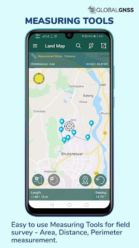
- Calculate the area and distance
- GIS data collector
- Survey using images for any location is available, with multiple export options.
- One set of attributes can be used across multiple surveys.
- GPS land area calculator
- Attributes can be imported from any other project or device.
-Post process of data can be performed with software like ArcGIS, ArcGIS online or
qGIS.
- WMS and WFS Surveyor tiled maps are supported, load topographic and orthophoto maps, geological surveys, cadastral information.
- Currently 4 methods of data collections are supported, GPS / GNSS location, map cursor location,GIS Tracker, point projection using angle and distance.
-Mapit GIS survey on multiple kinds of GIS maps.
-Various Export file formats for GIS data are CSV, KML, and GeoJSON.
- With external Bluetooth GPS/GNSS device connected, NTRIP/RTK data can be utilised for accuracy.
- Survey on online gis maps, and GIS offline maps(supports mbtiles.
- Direct export to Dropbox,Google Drive, FTP location.
- Import point, line and polygon layer in CSV, KML or geojson file.
- Possibility to view multiple layers including points, lines and polygons at the same time.
- Export in .SHP format.
- Export in GPX format.
- Possibility to group the data into survey layers - each survey layer may have a default set of attributes.
- Create new polygon or line features and measure details like area, length and perimeter.
- Backup management.
- Works with GEOID Model to provide elevation for a point.
- Receive Mock Location from 3rd party application.
- Coordinate System Geoid EGM96
Supports Android OS 4.4 and above
This application is made ads-free and hence it will increase your productivity. For any concern regarding the installation or functionality raise a ticket at: http://globalgnss.com/support/
Visit us at www.globalgnss.com.
แสดงเพิ่มเติม

1. ดาวน์โหลดตัวติดตั้ง MEmu และสิ้นสุดการติดตั้ง

2. เริ่ม MEmu จากนั้นเปิด Google Play บนหน้าแรก

3. ค้นหา Land Map - GPS Land Survey & M ใน Google Play
4. ดาวน์โหลดและติดตั้ง Land Map - GPS Land Survey & M
5. เมื่อติดตั้งเสร็จให้คลิกที่ไอคอนเพื่อเริ่มใช้งาน

6. ใช้ MEmu เพื่อสัมผัสประสบการณ์ Land Map - GPS Land Survey & M บนคอมพิวเตอร์ของคุณ
MEmu Play คือโปรแกรมจำลอง Android ที่ดีที่สุด มีผู้ใช้มากกว่า 50 ล้านคน มอบประสบการณ์การใช้งานแอป Android ขั้นสุดยอดให้กับคุณ เทคโนโลยีจำลองเสมือนของ MEmu ช่วยให้คุณรันแอป Android หลายพันแอปบนคอมพิวเตอร์ได้อย่างราบรื่น แม้แอปที่กินทรัพยากรเครื่องสูงที่สุด
จอใหญ่และกราฟฟิกสวยกว่า; เล่นได้นาน, ไม่ต้องใช้แบตเตอรี่โทรศัพท์หรือเน็ตโทรศัพท์.
ระบบปรับแต่งปุ่มคีย์บอร์ดและเม้าส์ตามที่คุณเลือก
เล่นมากกว่าหนึ่งเกมบน PC ในเวลาเดียวกันด้วยระบบหลายจอหรือ Multi-Instance manager.
Use Land Map - GPS Land Survey & M on PC by following steps: